


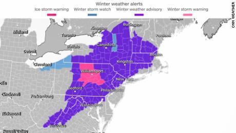
In the Northeast, freezing rain and sleet have blanketed parts of Pennsylvania and New York. Other areas in the region are getting walloped with snow. More than 30 million people across the region are under winter weather advisories on Sunday morning.
It said a quarter to a half inch of ice is expected to accumulate Sunday.
“Extremely dangerous travel conditions. Untreated surfaces will be very slippery. Isolated power outages are possible,” the NWS office said.

Residents are urged to avoid driving unless absolutely necessary.
“If you must travel, keep an extra flashlight, food and water in your vehicle in case of an emergency,” the NWS office in State College said.
By Sunday afternoon, the frigid mix of winter precipitation in the Northeast will transition to freezing rain for most and snow for some of the higher elevations before ending this evening,
Wide swaths of New England are expected to get anywhere between a glaze to a quarter inch of ice Sunday. But most of the ice accumulations are forecast to stay west of the major metro areas.
Severe storms and tornadoes possible in the South
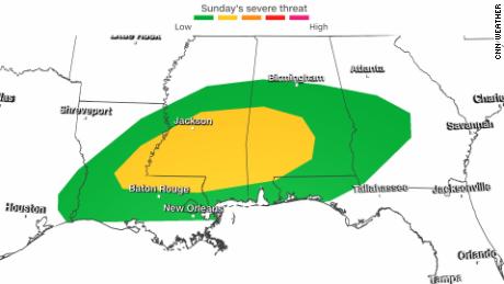
More than 10 million people from eastern Texas to the Florida panhandle could face strong to severe storms today.
“Damaging gusts, a couple of tornadoes, and isolated large hail will be possible today across parts of Louisiana, Mississippi, and Alabama,” the National Weather Service’s Storm Prediction Center said Sunday.
There is now a level 2 out of 5 risk for severe storms across Louisiana, Mississippi, and Alabama. Cities under this threat include Jackson and Hattiesburg in Mississippi.
Flooding could also be an issue for parts of the Gulf Coast, with some areas expected to get 2 to 3 inches of rain Sunday.
Frigid, arctic air engulfs the Upper Midwest
Sub-zero wind chills are expected to engulf much of the Upper Midwest on Sunday.

Wind chill alerts are in effect from Montana to Michigan’s Upper Peninsula, with wind chills of -20 to -40 degrees Fahrenheit is possible.
High temperatures will struggle to get above zero degrees for some northern parts of North Dakota and Michigan.
This bitter cold will extend into the Great Lakes on Sunday and into the Northeast by Monday and Tuesday.
On Tuesday morning, interior parts of the Northeast and New England could face sub-zero temperatures.
The brutally cold air and intense winds will lead to heavy lake effect snow downwind of Lake Superior and Lake Ontario.